
For the past couple of years we have done a month long ski vacation. We began our 2018 skiing adventure headed for our first destination the Pacific Northwest. On our road trips we typically like to drive 5-6 hours per day with some sightseeing stops along the way. Seems to work out well for us. As we headed to Moab, UT, we found ourselves passing within 5 miles of the Four Corners monument. Since, Alyssa hasn’t experienced the thrill of standing in four states at once, we made a detour.
The Four Corners Monument marks the spot where the states of Arizona, Colorado, Utah and New Mexico meet. The monument is run by the Navaho Nation and costs $5 per person. So, we took some pictures and walked around for a bit, 15 minutes later we were back on the road.


Hovenweep (Desered Valley) was our next stop. It is an ancient puebloan community with most of the structures dated from the 1200’s. This area was a thriving community at that time and had numerous settlements in the area, all within a day’s walk of each other. There is a visitor center, closed on the day we went, but there’s an easy self guided hike to view the structures around the canyon rim. The architecture was impressive, as they formed stone bricks and created towers many of which had curved walls.


We headed on to our over night stop in Moab, UT. Along the way we passed a large arch right along the road. So, we stopped for a photo opportunity at Wilson’s Arch. The arch was named after Joe Wilson a pioneer of the area who had a nearby cabin.


In the Moab area are a couple of National Parks, Canyonlands and Arches. We wanted to spend a half day at Arches before continuing on to our next stop. Arches is a small National Park that gets extremely crowded during it’s busy months of March to October. The day we were there, we were surprised at the number of people visiting as it was mid-week, winter, and chilly. We took the drive through the park stopping at the various points of interest to take a look. To view most of the arches requires you to get out of the car. The more known ones are viewable by short walks down a normally paved path. This park contains over 2,000 arches 10 of which are said to have fallen since 1977.


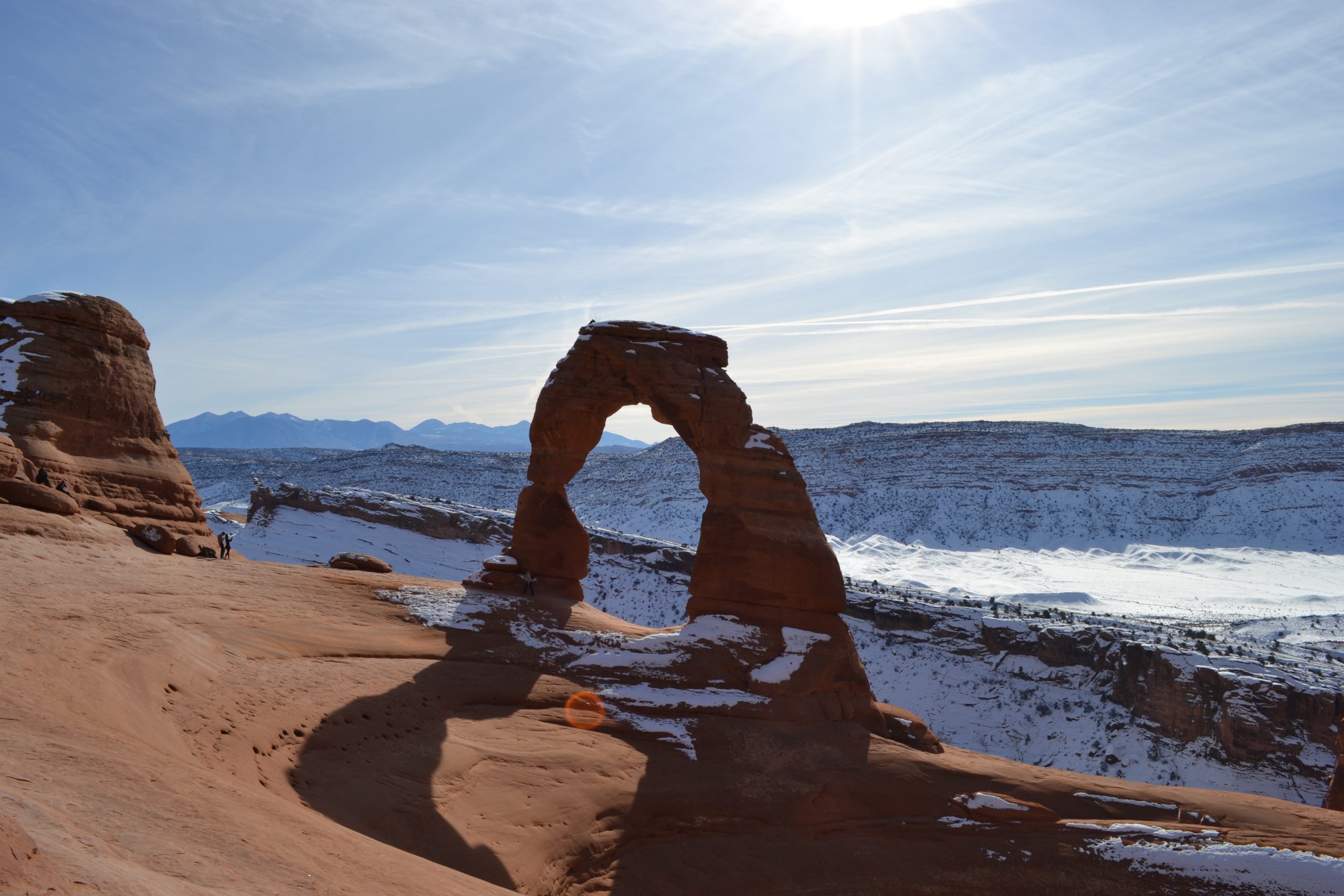
The most well known arch is Delicate Arch. This arch is what is depicted on Utah license plates. The arch can be viewed by walking down a short path to view from both the upper and lower viewing platforms or by doing the 3 mile round trip hike. We did the lower viewing platform and then opted to do the hike. It was 18 degrees when we started and it was really amazing to me how many others were braving the weather for this hike. It was a sunny day and we quickly warmed up and had to strip off a few layers. Unfortunately, neither Will nor Alyssa made it to the arch itself. Right before reaching the arch you must traverse a rock ledge. This ledge was snow packed and icy. Will wasn’t comfortable with the height of the rock ledge. and Alyssa did not feel her sneakers would give her a secure footing. I soldiered on and managed the rock ledge without incident, but then fell on my butt coming back down the steps. The arch was impressive and the hike was a really good workout. We also went on a couple of short excursions to see Double Arch and Sand Dune Arch. We plan to go back again when we have more time to explore this park.


The next day we headed out from Ogden, UT and saw signs for the Golden Spike monument. This was the spot where East met West, at least as far as the railroad was concerned. So, being that one of the men who drove in the Golden Spike was Leland Stanford then Governor of California and founder of Stanford University, we had to make a stop. (In case you didn’t know, Will is a Stanford graduate.) When all you are expecting to see is a monument commemorating the spot where the spike was driven in, we were pleasantly surprised to find a NPS visitor center. It costs $5 per vehicle or free if you have the National Park Pass. We got much more than we bargained for as there was a movie about the history of building a transcontinental railroad and the good and bad that came from that endeavor. They had some nice exhibits, the tools used to build the railroad and some artifacts from the workers and the different cultures involved. The West Coast team used a workforce of 10,000 Chinese immigrants and an Irish workforce that was responsible for grading the land. Then of course you can venture outside and view the lovely polished railroad tie marking the spot. The ranger declared it to be the world’s most polished railroad tie as he is responsible for polishing it himself. In the summer months, they also have the original train engines on display. In the winter, the engines are brought in for maintenance, but can still be visited by going to the locomotive museum.


As we continued on our drive we decided to spend a couple of hours in Boise, ID. I just had to take a look at “the Blue” also known as the “Smurf Turf”. That’s right the blue football field of Boise State University. This was the first non-green football field and was done originally as a marketing gimmick in 1986 by the school’s Athletic Director. Well, it worked, I’m not the only one who had to see the field. The turf has been visited by people from all 50 states and 37 countries. It had snowed that morning in Boise, so luckily they had started clearing the snow before we arrived and some of the blue was visible.


Our next stop in Boise was the Old Idaho Penitentiary. This facility held prisoners from 1872-1973 and held both men and women as well as a few children as young as 10. It is a really interesting place to visit and do your own self-guided tour. Hanging was the method of execution in Idaho and 10 men had met their fate here with the last being in 1957. We checked out the gallows, laundry and both old and newer cell blocks.


