
Didn’t take long and we were on the road again. Our first stop was Lake Sumner State Park. The park only had about 5 other campers, so it was a quiet spot to hang out for a couple of days. The park was mainly closed with the exception of the one campground and nearby lakeshore. So, we did the Discovery Trail again. It’s a short trail with some information signs about the local wildlife and the building of the dam. The dam was built in the 30’s, right as the dam was finished they had a massive rain storm that filled the reservoir in 48 hours. Looking at the current lake levels, that’s something that’s hard to imagine.

Day 3 found us in Carlsbad, NM. We needed a good WiFi connection, so we stayed at a private RV park in the city itself. We picked a windy day and went to Sitting Bull Falls. This area is run by the USFS and is in the Lincoln National Forest about an hour from Carlsbad. There is a $5/vehicle fee, but again we have the National Annual Park Pass, so, no charge. Since we had been to this area before, we didn’t do the upper falls trail hike and instead we did part of the Last Chance Canyon trail. That happened to be a really good choice on such a windy day. There is a nice spring area along the way and hiking through the canyon was impressive. We had the trail to ourselves until our return trip when we ran into a lady from Minnesota that was hiking in NM for a couple of weeks.


The Falls 150 Foot Drop
The wind was down the next day and we took off to the Carlsbad Caverns. We had done the Caverns a few years ago and this time decided to do a hike in the park. We set out to do a loop trail, which started at the Rattlesnake Canyon Trail Head. It’s a nice trail and true to form, we set out only to end up on the Southern Boundary trail. Yep, should have gone right, we went left. Well, we decided to continue on and get a feel for the boundary trail. Returned back to the junction and decided we weren’t tired, let’s go ahead and finish our original planned loop. And that my friends is how you turn a respectable 6 mile hike into something close to 10 miles. Our loop trail did have a little road walking involved and you’ll never guess who happened to be driving down that road at that time, our friend from Minnesota. What are the chances? She had been to the caverns and enjoyed them so much she was going to be returning the next day. We on the other hand were headed to our main destination, Big Bend National Park.


Lots of Walking in the Wash 
And Boulder Scrambling 

We decided to stay in Terlingua, Texas, which is a small town between both the National Park and Big Bend Ranch State Park. Both these parks are huge and even camping in the park requires miles of driving to explore the parks. You know how they say everything is bigger in Texas. The national park encompasses 1,252 square miles alone and the state park is a another 486 square miles. So, we decided to try and tackle the parks in sections to cut down on some of the driving.
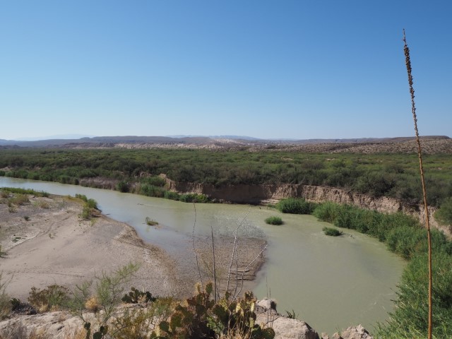
Day 1 – We drove the first day to the southeast side which is the Rio Grande Village Area. The park is set where the Rio Grande River bends separating the US from Mexico. We stopped at one of the visitor centers and the ranger recommended doing the nature trail that is inside the Rio Grande Village Camping area. What a surprise, there’s a nice overlook of the Mexican town of Boquillas and you can walk to the river and view some of the wetlands area. There were also some items for sale that are made by some of the Boquillas locals that are set out along the trail.


The Boquillas Port of Entry was closed, but typically you can cross the river by foot, boat, or burro. We headed over to the do the Boquillas Canyon trail. It’s a short trail that leads you to a sand dune beach and the mouth of the Boquillas canyon. You have to admire the entrepreneurial spirit of the Mexican nationals. Of course there were the normal crafts that were for sale, but also we treated to singing from the “Mexican Jesus” as well someone selling taco plates. We just yelled to the other side of the river (the Mexican side), placed our order and the guy brought our lunch over in his canoe. Now that’s what you call straight from Mexico.


Cooling off in the river 


Our Lunch Delivery 
Canyon doesn’t look like much from here
We wanted to get in a longer hike, so we set out to the Strawhorse Trail. We had been told by the Ranger that there wasn’t anything to see until you reach about 8 miles and there is no shade, (the official trail is a much longer 12-14 miles). From the trail map it looked like we could do a nice 6 mile loop combining the Marufo Vega and Strawhorse instead of just doing an out and back on one particular trail. Actually, it turned out much better than the ranger described. We saw the remnants from the aerial tram. Nope, not from a failed park attraction, but from the mining operation that had been in the park from 1915-1919. Our loop also took us through a slot canyon that gave us a little break from sun. This trail was hot and the sun was beating on us for most of the way in November. Bottom line make sure to take plenty of water no matter what time of year on this trail.


Our next hike was based on a friend’s recommendation, the Ernst Tinaja trail. This trail is located off a dirt road that was only recommended for 4 wheel drive high clearance vehicles We checked with the ranger before to ask about the current road conditions. She said we should be fine with our AWD SUV vehicle as long as we didn’t continue further down the road past that trail. The Ernst Tinaja trail is short and sweet. It is only .75 miles until you get to the end at the tinaja area. A tinaja is a depression in the rock that holds water.


Being that a weekend was coming up, we decided the state park might be a little less crowded and chose to spend the next couple of days there. We got a late start the next morning and knew we had a long drive ahead of us. We were going to a trail in the park’s interior, which meant about a 2.5 hour drive to the trailhead. Finally we arrived at the trail head. We wanted to do the smaller loop called the Cinco Tinajas trail, but missed our loop and ended up on the Leyva Trail. All right no big deal, it’d be a little longer loop. A lot of this trail is in a dry wash with hardly any cairns. Cairns are rocks that have been piled so that you know you’re still on a trail. Plus, there were a number of Longhorn cattle that are allowed to graze in the area. The cattle managed to obliterate any trail that we may have been able to follow. Good thing I had downloaded the trail map ahead of time and had it recording to track our progress. At one point, we had keyed in on the wrong landmark and realized we were headed in the opposite direction when checking All Trails. We may have still been wandering in the desert otherwise. We also had the trail map and a compass, but technology helped us to notice our mistake much quicker and got us back on track faster as well. We had decided that was enough excitement for one day and headed on back to Diablo.


Day 2 of our state park adventure went much more smoothly. We started with the Closed Canyon trail, which is the most popular trail in the park. It’s only about 1.5 miles RT and the canyon walls are on either side. No chance of us getting off trail on this hike. There’s a series of pour-offs in the canyon that require some scrambling, but it’s a fun hike. Just make sure that you can climb back up any pour-off that you scramble over.


Yes, I made it back up on my own
Next we headed over to the HooDoo’s Trail. Hey it’s no Bryce Canyon, but hoo doos are always kinda cool. And at only 1.1 miles RT, it’s another quick and easy one.


We then headed over to do a small loop off the East Rancherias trail head. Okay, our small loop in this case was 6 miles. This is a favorite trail for mountain bikers and we ran into a few of those, but no other hikers. This is another trail that you’ll want to have plenty of water. There wasn’t any shade and when we got back the car was reading 91° for an outside temperature.


the Crystal Trail
If you don’t do anything else in the State Park, make sure to take a drive on FM170 (River Road). It is the paved road that goes east to west through the park and mainly follows along the Rio Grande, such spectacular scenery.

Sunset from Diablo 


We were back at the National Park the next day. We went to tackle some of the sites along the Ross Maxwell Scenic Drive.

Sam Neil Ranch 
Sam Neil Ranch 
Sam Neil Ranch 

Homer Wilson Ranch 
Homer Wilson Ranch 
Homer Wilson Ranch 

Mule Ears
Ross Maxwell is another pretty drive which ends at the Santa Elena Canyon. There’s a short hike that goes into the canyon for a bit, but it’s worth it to just walk from the parking area to the river to view the 1,500 foot towering cliffs. Do those Mexicans know how to build a wall or what? The hike starts with a creek crossing. The water level was thigh high when we crossed. The trail then climbs up a series of switch backs along the side of the cliff. This is about the point where Will decided he had enough. I continued on, the trail continues along the cliff for a ways until descending back on the river bank until you reach a point where it’s just nothing but canyon walls.


Hiker Crossing

Ah, a nice relaxing float trip, why didn’t we do that? 
We drove back on the Old Maverick Rd. It’s a dirt road, but gets a lot of traffic that it’s pretty well packed down and not too bad a drive. It goes past Luna’s Jacal. Gilberto Luna lived in this jacal until 1947 when he finally passed away at 108 years old.


We were having a good time hiking around and decided to stay a few more days. New Mexico had gone back on lockdown, which was going to alter our return trip plans. So, why not extend our time in Texas a little longer. Next up was the Window Trail. I have to say this trail ended up being a favorite for both Will and I. It is set in the Chisos Mountains in Big Bend. This mountain range is the southern most mountain range in the continental US and has a vastly different climate then the desert area that surrounds it. The Window Trail begins behind the park store at the Chisos Visitor area. It’s downhill all the way to the “window” view of a pour-off and you loose about 1,000 feet of elevation. So, the one negative about the trail is it’s uphill on the return. This trail has a lot of shade, canyons, and views. It’s 6 miles RT, but you can also start this trail at the amphitheater near the Chisos Campground. Starting at the amphitheater saves you about 2 miles and also avoids the steep uphill back to the Visitor’s Center. We also did the Window View trail. This is a nice quarter mile paved option for those who aren’t into hiking, but who appreciate a nice view.


Mexican Jay 
Mexican Jay 


The Window at the end of the trail
Then we did the Mule Spring trail. This trail gives you a closer look at the iconic “mule ear” rock formation and eventually ends at a spring. Didn’t care for this trail. There is no shade and the view of the mule ears is actually better from the overlook and the spring is very overgrown and not much to look at.


We also did a quick hike into Tuff Canyon. Easy hike 1 mile RT along the canyon floor.


Another Great View of Mule Ears
Moving day, since we were staying longer we decided to move to another RV park that we had come across and save ourselves $15/night. Since we moved only a few miles we still had time to get in another hike. We managed to score the last parking spot at the trailhead for the Lost Mine trail. There’s no parking allowed on the road for this popular trail, so we felt very lucky to get the spot. The story is that there were some Spanish explorers that discovered ore and started mining. They enslaved Chizo natives to work the mine and blindfolded them when leading them to the mine to keep the mine’s location a secret. At some point, the slaves revolted, killing the Spaniards and sealing the mine’s entrance. The views from this trail are great, but you are constantly walking along the edge of the mountain with some steep drop offs in places. Will got in a little over a mile before he called it quits on this one. I continued on and enjoyed the trail and the views. Will just did laps of that 1st mile until I made it back down.


Back hiking the next day with all things Burro. We started with the Upper Burro Mesa Pour Off. This was a trail that we had thought about doing, but really made the cut when it was recommended by some fellow hikers. It has a lot of boulder scrambling and some cool canyon views. You eventually reach the end of the trail which is the pour off. You may be wondering what a pour off is, when it rains and water comes through these canyons, it has to go somewhere. It usually comes through the canyon too fast to seep into the ground so it goes over the rocks settling in some of the tinajas and continuing downhill until it pours out over the side of a cliff. So, from the upper trail you can see the edge of the pour off, but you don’t really appreciate the 100 foot drop until you see if from the lower trail. So, yes the next trail was the Lower Burro Mesa Pour Off. The lower one is only about a mile RT and is flat.


It’s 100 feet down


And 100 feet up 
To finish the Burro series, we did the Burro Spring trail. There isn’t a lot of shade on this trail either. It does end with a nice overlook of a spring area, but other than that; I didn’t find this trail all that interesting.


For our last day hiking in Big Bend, we took it a little easier. We started with Balance Rock. The trail head is off Grapevine Road, which is 6 miles down a dirt road. The road got a little sandy in a couple of places, but there were a couple of passenger cars that were able to make the trek. Balance Rock is 2 miles RT. It is flat and easy until the last quarter mile, which requires some boulder climbing to get to the rock. Glad we got there early enough, this trail was really getting crowded as we passed a number of people on our return trip.


Super Human Strength 
We drove over to the fossil area and drove the Dagger Auto Trail. Neither was particularly exciting, but the fossil exhibit had some casts of dinosaur skulls that kids would probably enjoy. And there is a picnic area, which that day was downwind from the vault toilets. Not the wisest picnic location in my opinion. To get some additional miles in for the day, we headed over and did the Ward Spring trail. You’ll see some interesting rock formations on the way, but the spring is not visible.


Leaving Big Bend, we went a couple of hours north to the Davis Mountain State Park. This park is right outside Fort Davis, TX. It’s a smaller size park, but does have a number of hiking trails and the Indian Lodge. The Indian Lodge is a white adobe building that was built in the 1930’s by the CCC. Looks like it would be a nice place to stay, if you’re not into camping. The next morning, we had planned to hike over to the Fort Davis National Historic Site. The maps gave conflicting info on how long of a hike it would be, but we set out anyway. Got to the edge of the fort property where it a sign said it was another 2 miles to the fort, well, we had already done 3.5 miles. So, we decided to just hike back to the campground and then drive to the fort. We hadn’t really wanted to do more than 10 miles that day.


The fort is National Historical Site and so, we didn’t have to pay the $10/person fee with the Annual pass. The fort was occupied from 1854 until the time of the Civil War when it was abandoned for a few years. The army eventually took it over again until 1891. The hospital was supposed to have been one of the best west of the Mississippi in its day. Let’s just say that when they described the type of medical care that people received during that time, I’m glad our medical training/care has advanced.


The officers had some nice digs 

Hospital 
Well, it was finally time to start heading back home. We were headed back to the Carlsbad area again. We stayed in Queen, NM. Queen is about an hour southwest of Carlsbad. It’s also about 15 miles from the northern entrance to the Guadalupe Mountains National Park. We wanted to check out this area a little further and see what it had to offer. Plus this area of the park is more isolated then the Pine Springs area and therefore less crowded. Got to the RV park on a cold, foggy and rainy day. Luckily, the next morning the sun was shining, but the wind was up. It was a nice drive down to the Dog Canyon area of the park. Our annual pass saved us another $20 bucks, yeah. We talked to the Rangers and they recommended we try the Tejas Trail. It’s a beautiful trail and you are hiking in the canyon, which provided us some shelter from the wind. We only did 5 miles because Will wanted to get back before the Queen Café closed and try a burger. The owner claims to have the best burger in NM and they were really good.


We finally made it home and parked Diablo. He is now resting and awaiting another adventure when the weather warms up.