
Our next stop was Page, AZ. The wind had died down considerably and made for an easy drive. I had found us a site at a newer RV park on Antelope Point. While there is no shade at the park, it does have some nice views of the surrounding area.

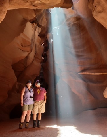
The next morning, we had a tour scheduled for the Upper Antelope Canyon with Adventurous Antelope Tours. The Upper Antelope Canyon is a slot canyon that is only around a half mile in length, but the way the light reflects off the canyon walls it makes it a photographer’s dream. This is another guided only tour as it is located on the Navajo Nation. Our guide was very knowledgeable and knew some of the best spots to get great photos and the history of the canyon as he grew up in the adjacent village.


The land is owned by a Navajo woman. In the 1920’s, she discovered the canyon while looking for her lost sheep. The family still owns the land and runs the majority of the tours. In this area, there are a few slot canyons. I believe, all now require a guide to go through. The 3 main canyons, Upper Antelope, Lower Antelope, and Canyon X, all have there are pros and cons. The Upper Antelope is the busiest but doesn’t require climbing ladders. The hard part is returning to the vehicle where you need to climb some stairs to return. From what I understand Lower Antelope Canyon involves ladders to get down into and out of the canyon. Canyon X is the newest tour, and less expensive and less crowded than the other two.


It’s the heart of the canyon.
The Navajo are still being very cautious as COVID hit their people very hard. Masks are still required, indoors without exception and in most group settings, even when outdoors.

Lake Powell is also located in Page, AZ. We were staying at the RV park right by the marina and decided to find a boat tour to get out on the water. The water level in the lake is currently at a historic low. Because of the water levels, we were not even able to walk down to the boat docks. They shuttle you down from the parking lot on golf cars. The canyon walls are now 70 feet above you from the water.

The marina is on top of the canyon walls.
It was a nice little one-hour boat tour into another section of Antelope Canyon. The controversy surrounding the creation of Lake Powell and the Glen Canyon Dam in the 1960’s has again started to come up in the news. Because of low water levels the dam may soon be in danger of not being able to make power and may become a dead pool. Then, there is the fact that Lake Powell is the main water reservoir for about 40 million people in the lower Colorado basin states of Arizona, Nevada, California, and eventually Mexico. It is a frightening sight to see this marina that was only opened in 2004 and both the water and the boats aren’t even visible from the parking lot.


Check out these houseboats.
The next morning a storm came through and the temperature dropped a good 20 degrees from the day before and the wind was again gusting like crazy. We went out in the morning and fought the winds to visit Horseshoe Bend. The Bend is located on Federal property, but the City of Page is the owner of the parking lot. This place was busy, even in spite of the lousy weather. You go through the toll booth and pay the $10 parking fee. Park your vehicle and then it’s only a 15–20-minute walk to the overlook. The overlook gives you the iconic view of the 270° turn of the Colorado river from 1,000 feet above.


We picked another short hike in Page and this time only had to contend with a few people. It was the Hanging Garden trail. It’s 1.5 miles and not much elevation change. There are few spots that were very sandy, but other than that a very easy trail. At the end of the trail is the spring area with ferns growing off the rock. We had enough of being sand blasted and called it quits for the day. It was incredibly windy that night, but Diablo held on and weathered the storm.


We even found a car wash that was Diablo sized.


Some nice views on the drive from Page.
We had planned on leaving Page and going down to the Flagstaff area, but the wildfire season has started early this year. There was a large fire in the Flagstaff area, and they had closed the main route from Page. So, Will found the Homolovi State Park that was along our new route. We spent the next morning exploring the Hopi ruins at the park. We also walked down to the cemetery from the Morman settlement established there in the 1870’s. The settlement was washed away in a flood in the late 1880’s.


View of the San Fransico Peak in Flagstaff.

I was always worried about getting into quicksand as a kid.

Gravestone from the Mormon cemetery. 
Pretty sunset at the park.
Walnut Canyon is a national monument where there are a number of ancient Sinagua Indian cliff dwellings. We had always passed the sign when traveling up and down 1-40. This time we decided to make the trip there. The visitor center has a good video of how these people lived in the high desert climate. The Island hiking trail will lead you down to view a number of the cliff dwellings. The trail is paved and only a mile round trip, but there are over 700 stairs to climb down and back up, making it a pretty decent workout. Being that these are cliff dwellings, they are located on the side of the canyon walls. Needless to say, Will did not join me on this hike. Walnut Canyon is a good place to spend a couple of hours and there are a couple more moderate hikes in the park as well.


Walnut Canyon, on the right is the Island

Some of the cliff dwellings.

That is the visitor center and there are steps going all the way up.
Our final stop on this trip was to the Sky City Casino RV Park on the Acoma Pubelo in New Mexico. For $22/night you get full hook-ups, including cable and WiFi. It was also Will’s birthday, so we headed on over to the casino to see what deals he could get. He ended up winning enough to pay for dinner, so I call that a win.

The last day before heading home we backtracked a little to Grants, NM. We visited the New Mexico Mining Museum, which does a great job of explaining what it was like to work in one of the area’s uranium mines.


And then we figured what the hell, we have a little time. Let’s go hike the Continental Divide Trail. Okay, so it was more like a 2-mile section of the CDT. We made it to the post and rang the bell. Feeling accomplished.

View of Mt Taylor 11,310 
That rectangle section is an open pit mine as viewed from the trail.


Leaving the trailhead, we saw this big guy warming himself on the road. Just glad we didn’t meet him on the trail.
